image: Yemen Wrath
introduction
Saudi Arabia is the most important customer of Belgian weapons. In the last 30 years about a third of Belgian arms exports went to Saudi Arabia. In 2019 between 50% and 75% of Belgian arms exports had Saudi Arabia as their final destination. These exports have been contested in court, and the Council of State has now suspended all arms exports destined to Saudi military units active in the war in Yemen. More specifically, this concerns the Saudi National Guard.
According to the Walloon regional government, which granted the export licences, the Saudi National Guard is only active inside Saudi Arabia and not in military operations outside the country. It would therefore not participate in the war in Yemen, but only be involved in the protection of the Saudi borders. This investigation will prove this to be false.
In this report we document the involvement of the Saudi National Guard in a (failed) military operation inside Yemen. In late August and early September 2019 it supported Yemeni fighters in an offensive against the Houthi in the north of Yemen towards Kitaf, which got blocked in Wadi Aal Abo Jubarah or the Jabara valley. We also document the widespread use of Belgian weapons by the National Guard during its military activity in Yemen. We have collected video reports, reconstructed events and verified locations and weapons based on these videos. Most of the Houthi media accounts on YouTube from which we obtained our source material have recently been taken offline, but we have reposted the most representative videos used in this investigation.

Belgian weapons & ammunition
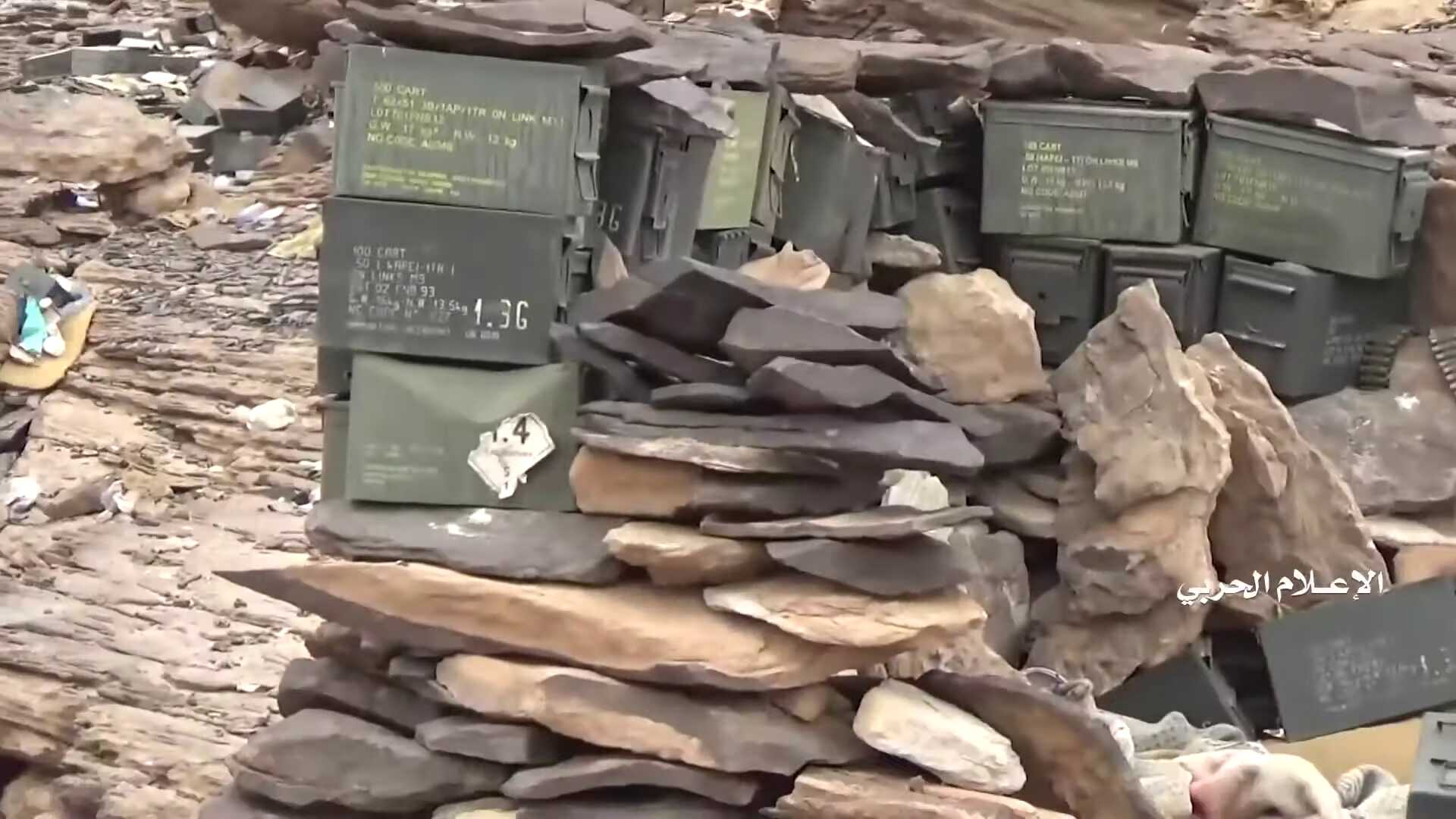
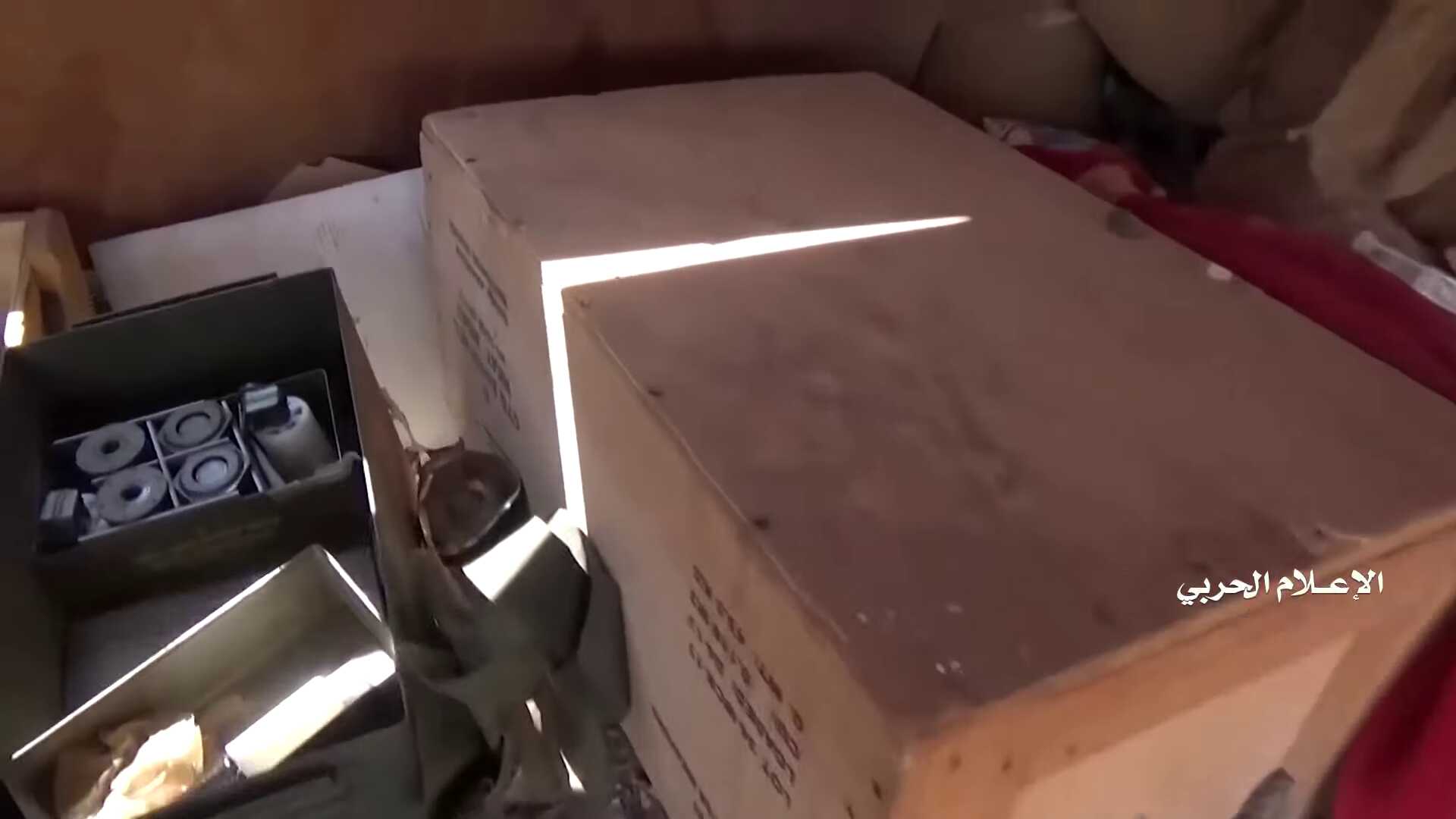
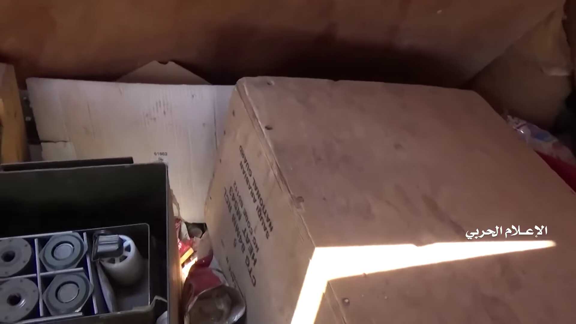
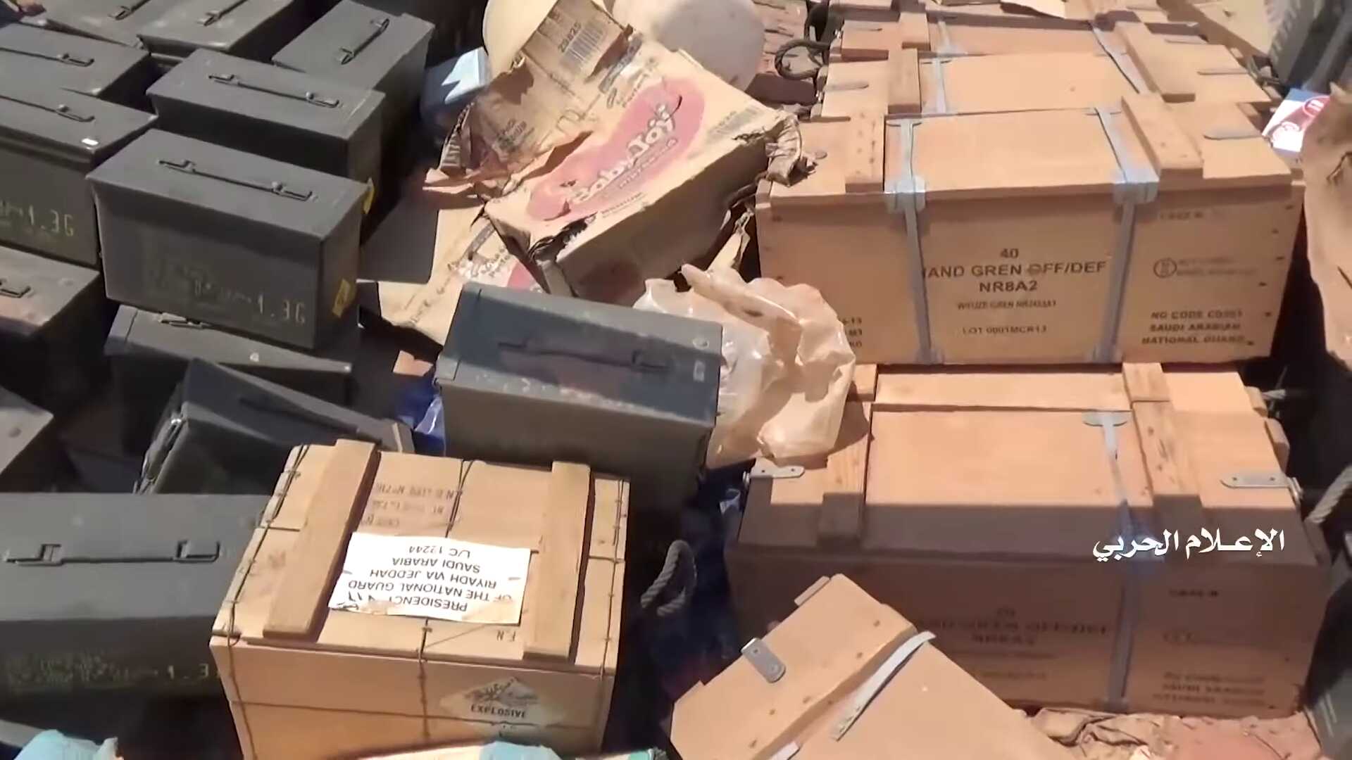
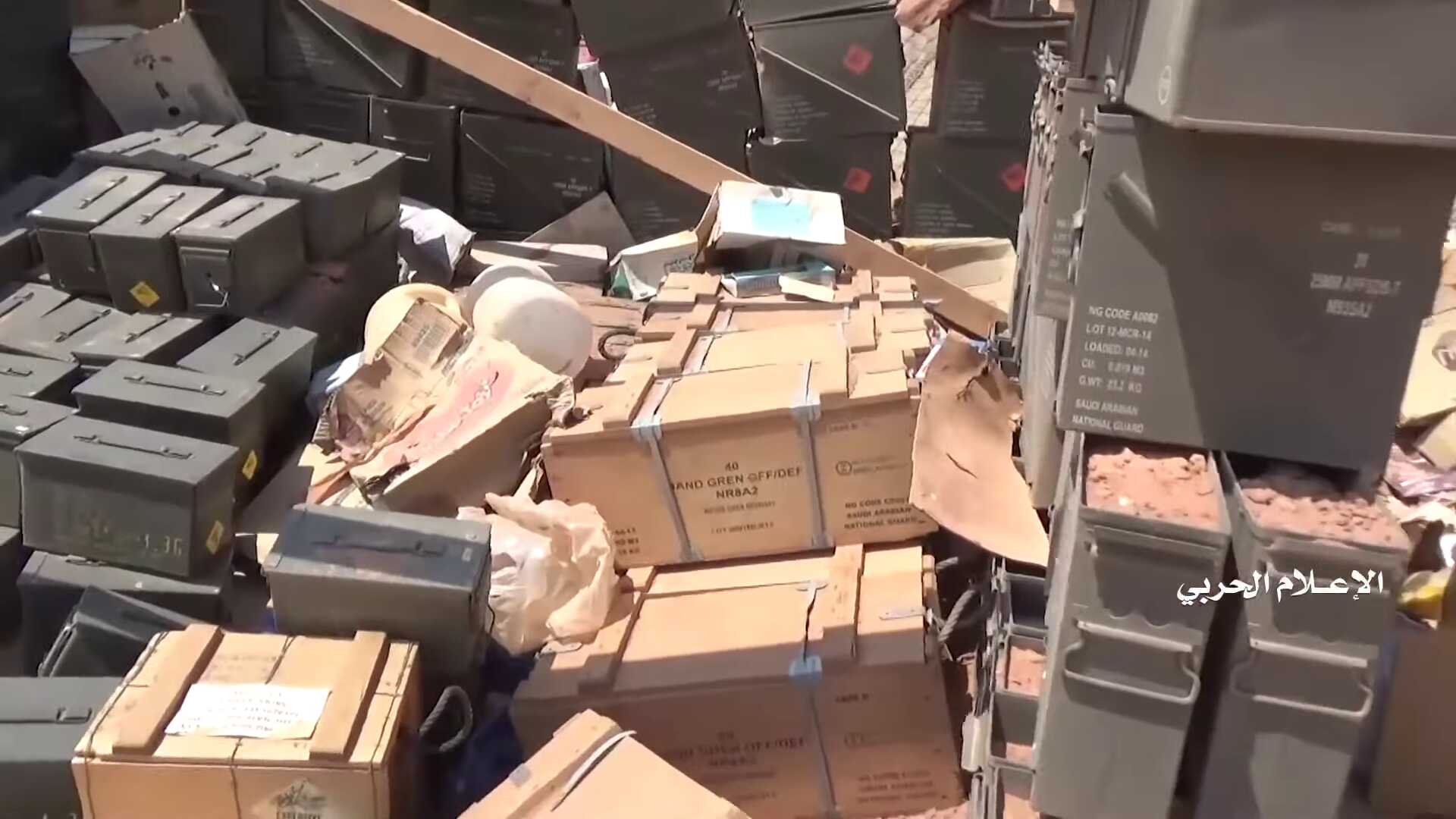
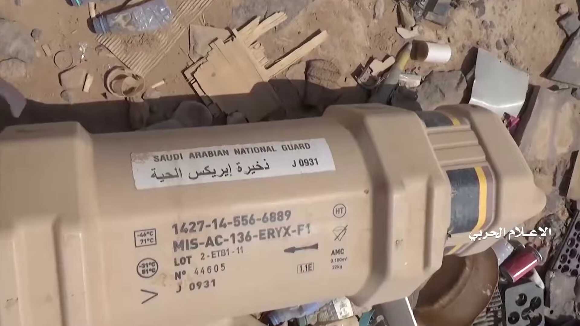
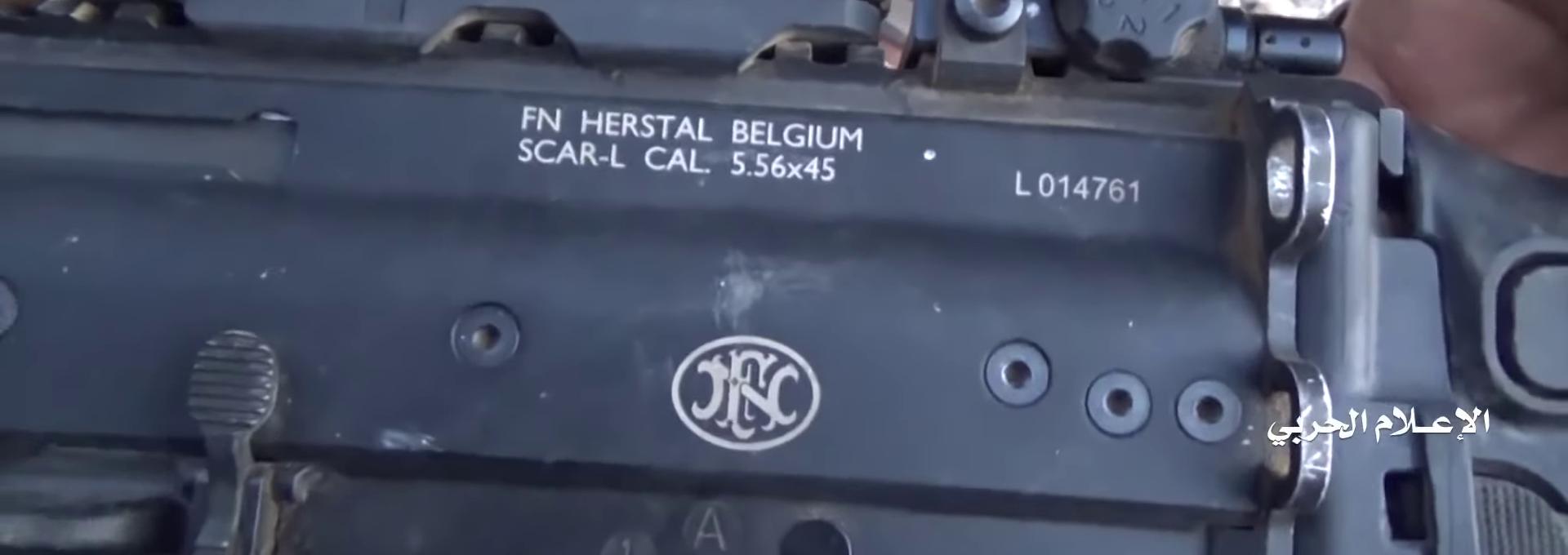
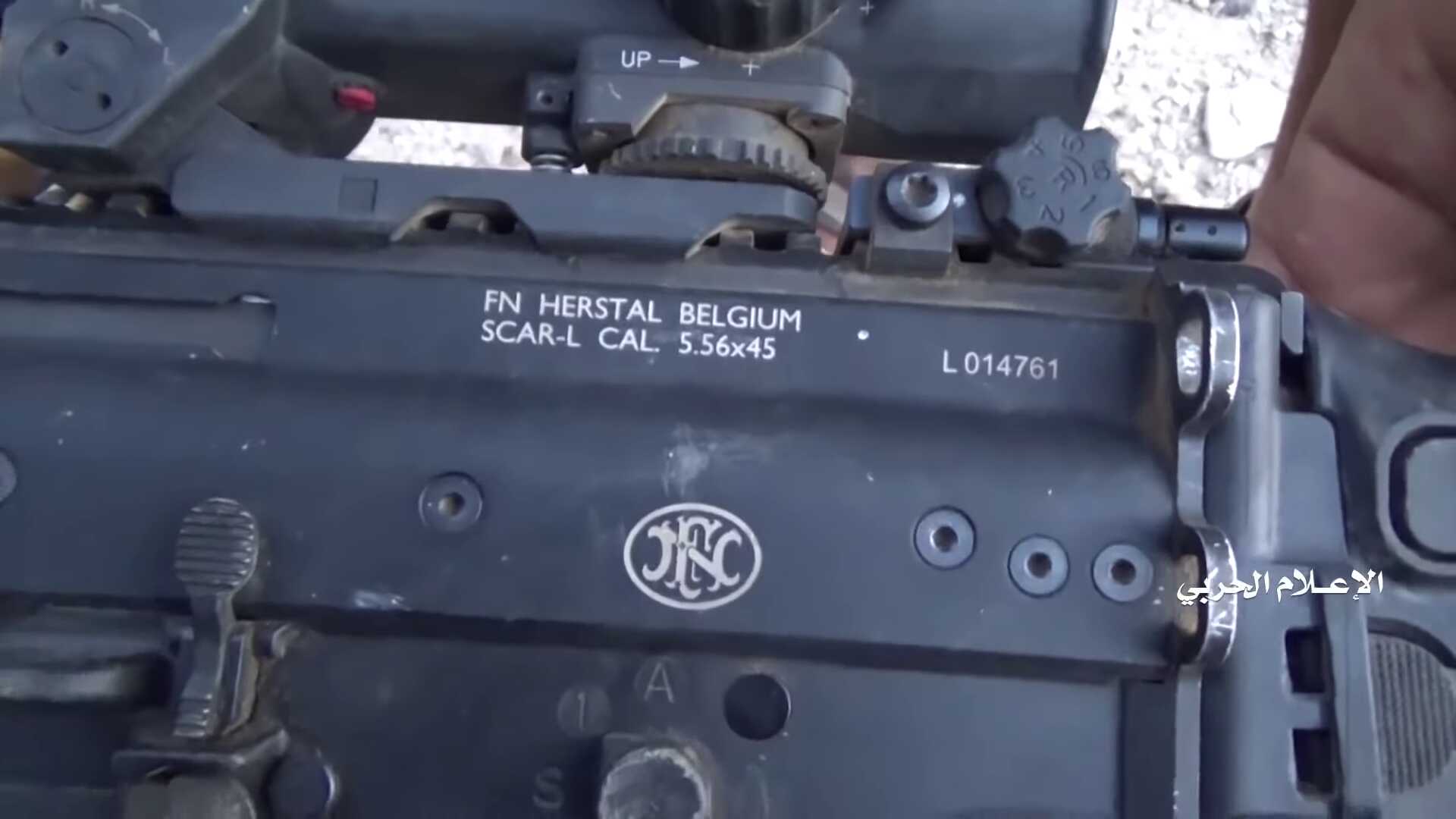
On these videos we could identify a wide range of Belgian weapons and ammunition used at the Saudi outposts in Yemeni territory, as well as by Saudi soldiers participating in the offensive by the Saudi National Guard. Several of the ammunition boxes clearly indicate the Saudi National Guard as destination. The presence of LAVs, a type of armoured vehicle only used by the Saudi National Guard, in the Saudi offensive and near the outposts proves that this military force is actively engaged in military operations inside Yemen.
We spotted the following weapons and ammunition of Belgian origin:
FN Herstal
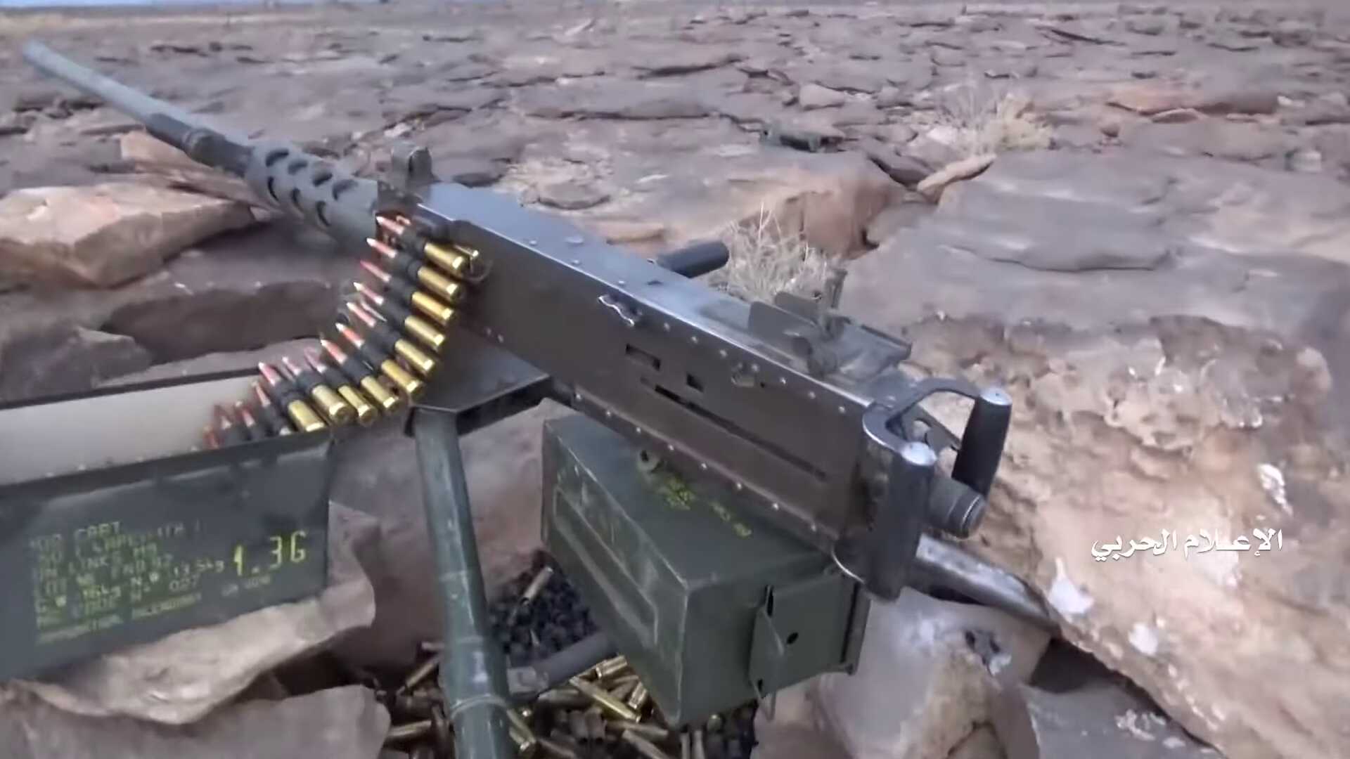
FN munition, recognizable by the FNB in the lot number, can be seen in diverse calibres. Here we see 7.62mm munition, used with the FN MAG and other machine guns, and 12.7mm munition (indicated by the 0.50 inch), which is used with the M2HB.
It is possible that some of this FN material is produced in the US. However, it should be clear from these observations that any FN material exported to Saudi Arabia and especially the Saudi National guard, can end up in military operations in Yemen. Further, according to the export statistics a lot of weapons have been exported directly from Belgium to Saudi Arabia. The records of dangerous goods aboard the Bahri ships, obtained earlier through a Freedom of Information-request, listed similar munition.
Mecar
Other
Geolocating a conflict
Most images were spread on 28 and 29 September 2019 after a press conference by the Houthi. On this press conference the Houthi spokesperson Sarea presented their military victory over the Saudi and Yemeni forces. He stated that three military brigades of the Yemeni army and a Saudi regiment had surrendered and several thousands of soldiers had been captured in an offensive near Najran (Saudi Arabia). He also claimed that they occupied about 150 km² inside Saudi Arabia. The Saudi government denied the capture of its troops and of its territory.
While the images clearly showed captured soldiers and destroyed material, several media outlets were cautious with the story as they could not verify the claims of the Houthi, such as the amount and origin of the captured soldiers, and the location or timing of the images. At that point it was not clear if some of the images were made in Saudi Arabia or in Yemen, if they all originated from the same events or if it was an assemblage of images from different events. In this report we verified the images as much as possible and present what can be reconstructed about the events.
These events can be divided in three phases.
- A first phase in which Yemeni militias went on an offensive towards Kitaf, but got surrounded and besieged in the Jabara valley. They are Yemeni fighters, but in practice trained and armed by Saudi-Arabia. Their vehicles bear the insignia of the Saudi military and the Saudi military provided air support throughout the operation. It is therefore difficult to consider this a purely Yemeni operation. However, actual involvement of Saudi soldiers on the ground could not be detected in this first phase.
- This changed in the second phase where the Saudi National Guard tried to break the encirclement, but had very limited success and was forced to withdraw.
- In a third phase the Houthi continued with a counter-offensive, named operation Victory from God, and captured a range of Saudi positions north of the Jabara valley, in and near the Alfare valley, but still inside Yemen.
All images which we could geolocate are situated inside Yemen. No evidence could be found of a cross
-border counter offensive inside Saudi Arabia.
The following map shows the locations of the images verified in this report.
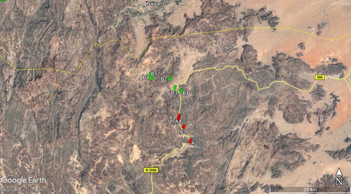
image: Copernicus (via Google Earth)
-
23-29 August 2019
The start of the offensive
According to statements of both Yemeni fighters and the Houthi, the offensive of the Yemeni militia started on the evening of 23 August. They entered the Jabara valley on 26 August and their ensuing encirclement continued until 29 August. The bulk of this Yemeni force was formed by the Fatah brigade and strengthened with elements from other brigades. The Fatah brigade consists mainly of Yemeni mercenaries from Taiz and Ibb, but was established under Saudi sponsorship in 2016 to fight the Houthis in the Najran border area. It is recognized as a brigade by the Yemeni army, but in practice acts under Saudi control. Yemeni fighters state that 1500 to 2000 fighters were captured.
The footage of the fighting during this first phase is more limited and difficult to geolocate. It shows mostly the capture of makeshift fortifications, probably in the hills around the Jabara valley, and the destruction of M-ATVs. The material released by the Houthi further shows the aftermath with images of surrendering and captured Yemeni fighters and captured vehicles.
Based on the footage released by the Houthi, these Yemeni fighters were equipped with military vehicles (Oshkosh M-ATV's, M113's, ... —all with markings referring to the Saudi armed forces) and Toyota pickups. In this phase we cannot detect a direct involvement on the ground of the Saudi National Guard, although there is Saudi involvement through air strikes (visible on some of the images of the surrendering fighters). Therefore we did not put extensive effort in geolocating this footage. Also, the reporting from both the Yemeni fighters participating in the advance and the Houthi about the events seem to corroborate.
-
around 01 September 2019
The Saudi advance & retreat
In the second phase the Saudi National Guard undertook an effort to break the siege and advanced with a column of mostly LAVs and M-ATVs over the road between the Alfare valley and the Jabara valley. The first visual evidence of this advance is a video posted on the Facebook page of Sheikh Radad Al-Hashimi, commander of the Fatah brigade, on 1 September 2019. Descriptions on the reposted images on a Houthi-YouTube account (now taken offline) suggest that this advance happened on 28 August, but this date cannot be verified. We could not geolocate this video precisely, but the view of the mountain range is similar to that on another video fragment made by the Houthi in the Jabara valley after the battle. Further, this column can be seen on the Houthi-made report about the events.
-
Three Saudi M-ATVs ambushed on the route between the Alfare valley and the Jabara valley
Three M-ATVs destroyed on the route towards the Jabara valley belong probably to the rear guard of this advance. These M-ATVs can still be seen on the satellite pictures and were heading south. As the Houthi report on the events in and on the road to the Jabara valley seems to respect the general chronology of events, this suggests these M-ATVs with Saudi soldiers belonged to this Saudi advance.
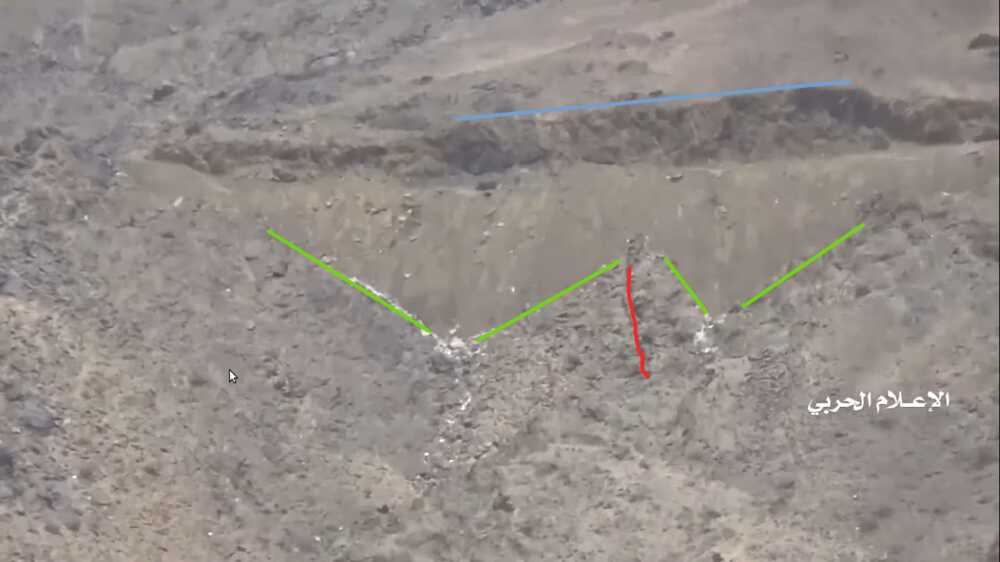
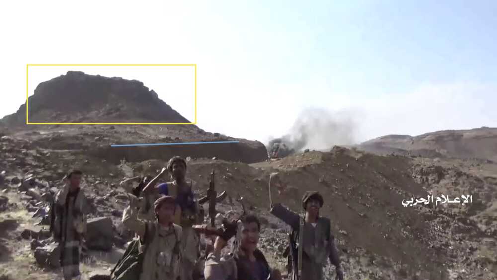
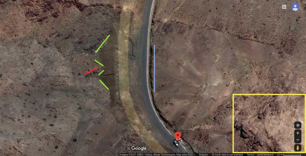
This Houthi-made report shows from 14:49 to 18:31 the capture and destruction of 3 M-ATVs. The wreckages of these M-ATVs can be found on Google maps-satellite pictures and were not yet present on the imagery from 21 July 2019. The video fragment starts with a shot on the road and zooms in at the ambush spot before the turn.
We have indicated landmarks with visual markers:
- — the two triangle-shaped dirt slopes (green)
- — the series of rocks in between the slopes (red)
- — the steep rock at the other side (blue)
- — the hill east of the road (yellow)
Also the shape of the road (2 left-hand turns with a faint right-hand turn in the middle – visible from 15:22 to 15:30) and the position of the M-ATVs fits the video fragment.
We can therefore conclude that these events took place at this spot of the road between the Alfare valley and the Jabara valley.
-
The LAV wreckage in the Jabara valley
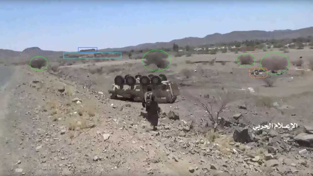
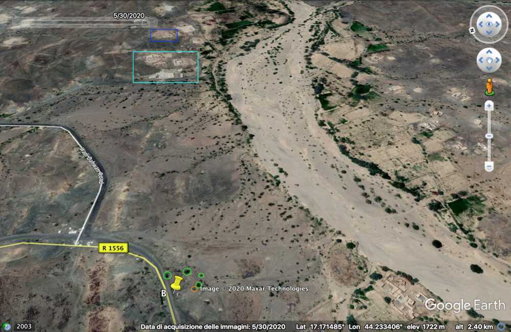
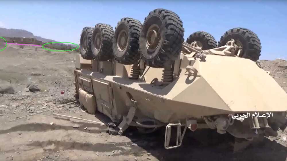
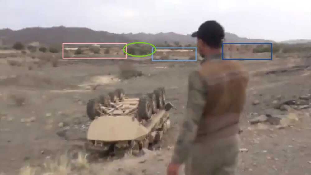
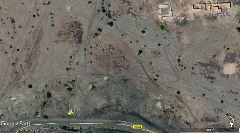
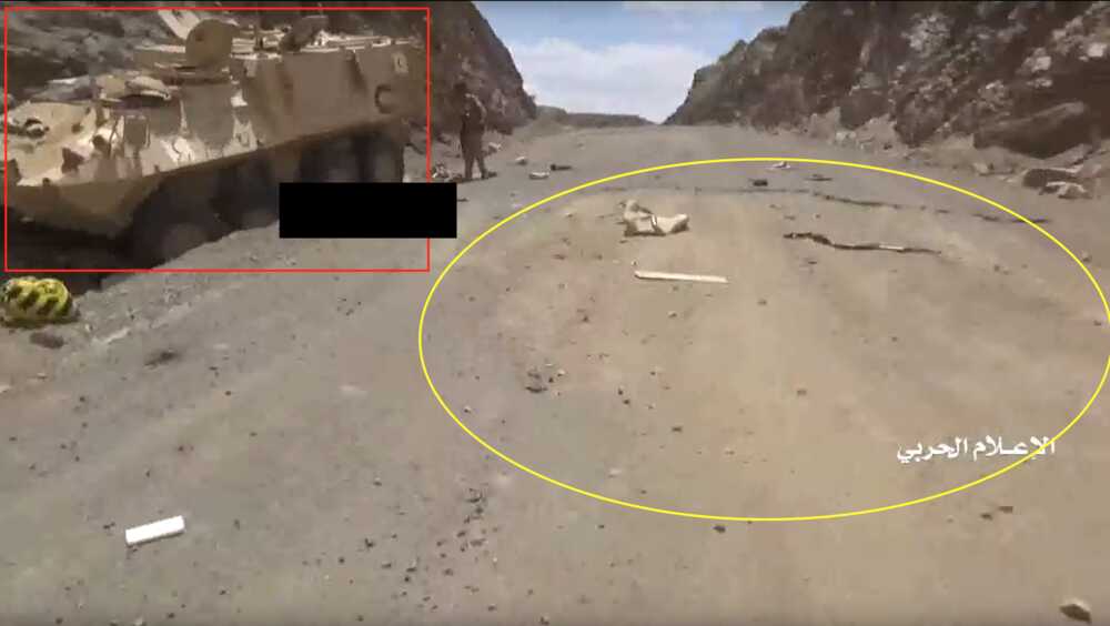
The wreckage of a LAV at the entrance of the Jabara valley provides visual evidence of the attempt by the Saudi National Guard to break the siege. This wreckage is visible on Google Maps, while it is absent on earlier satellite pictures. Some Houthi reports on this battle show this wreckage and its surroundings in detail. This allows us to verify that the vehicle at this spot on the satellite pictures is indeed a LAV belonging to the Saudi National Guard.
It is visible on the following videos:
The video fragments showing this LAV do differ from the satellite pictures: on the satellite picture the direction of the LAV has changed and it seems to have been flipped again onto its wheels. A possible explanation is an attempt to salvage or to remove this wreckage. However, visual details in the video of the surroundings do concur with the satellite image and suggest it concerns the same LAV.
In the first view towards the east the nearby bushes (green) and debris (orange) concur with the satellite imagery. Also in the background some buildings (light blue) are visible, as well as an additional one on the hilltop (blue).
The second view towards the southwest is visible on several videos from slightly different viewpoints. In this view bushes (green) and buildings (pink, light blue and dark blue) match the satellite pictures.
-
LAVs during retreat under fire
The Houthi reports on this second phase of the battle further show the retreat of LAVs from the Jabara valley towards the Alfare valley in the north, whilst under fire.
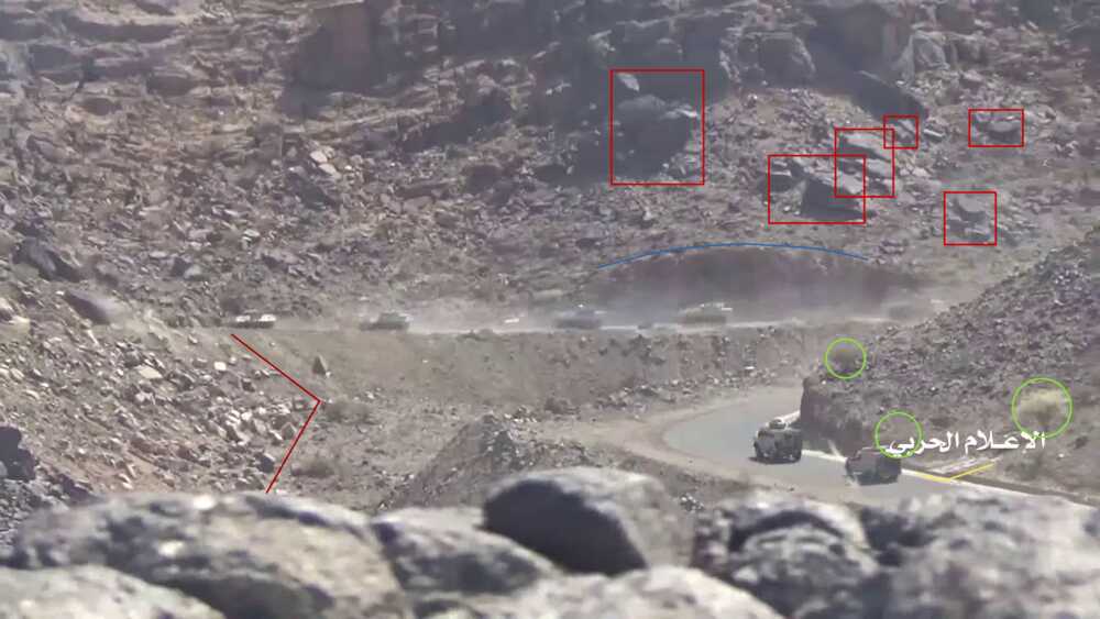
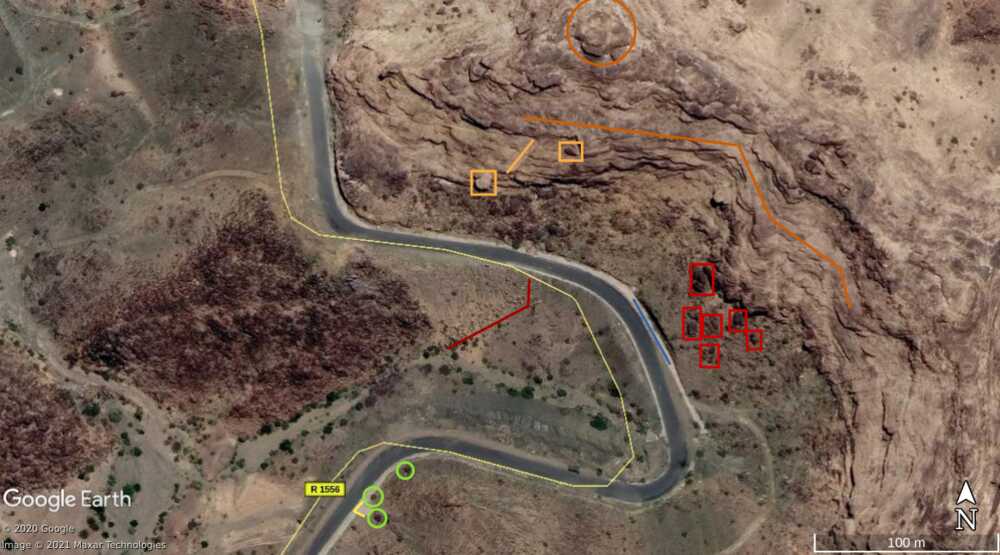
The Houthi-made report shows (from 20:08 to 20:58) several LAVs and other vehicles driving at high speed towards the Alfare valley in the north, whilst under fire. This report shows similar scenes at other spots, but this particular scene can be easily verified due to the particular shape of road, a rectangular shift along the mountains. Further we can also point to several visual details which match with the satellites images.
The close-up of the first turn shows a small flat area before the turn (yellow) with a vegetation pattern (green) similar to the satellite imagery. Also the steep side near the road (blue) and above it the pattern of rocks (red) on the slope before the steep mountain side matches.
-
Destroyed LAVs on the route between the Jabara and the Alfare valley
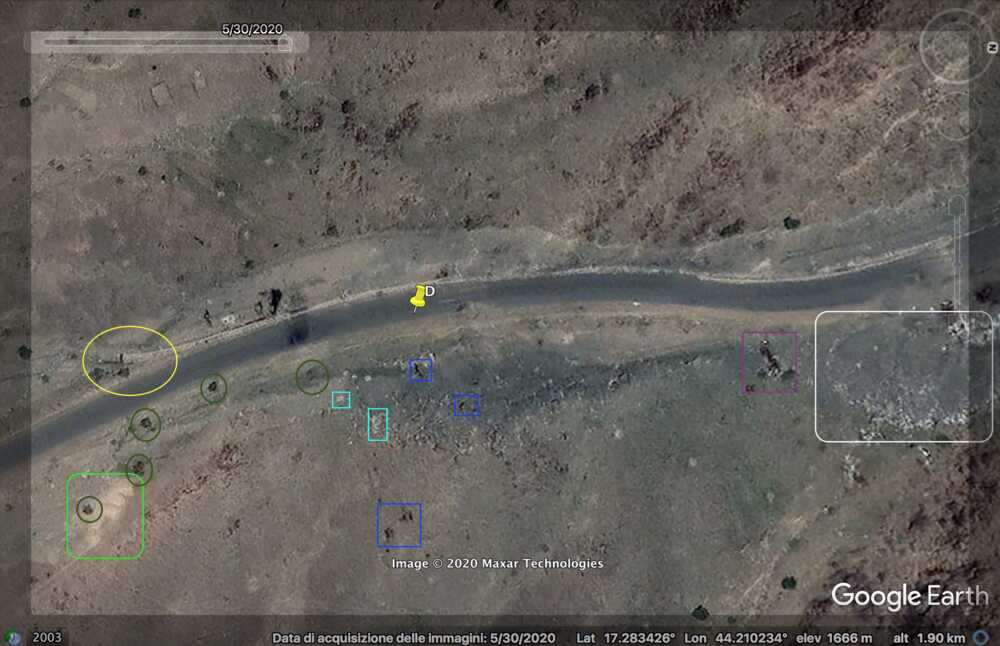
During this retreat, multiple LAVs seem to have been destroyed along the road. Several images in this video can be geolocated and linked to wreckage visible on the satellite pictures.
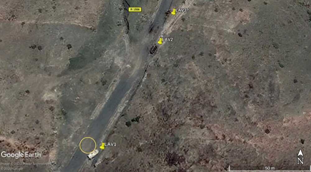
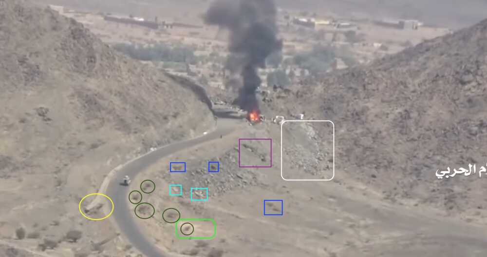
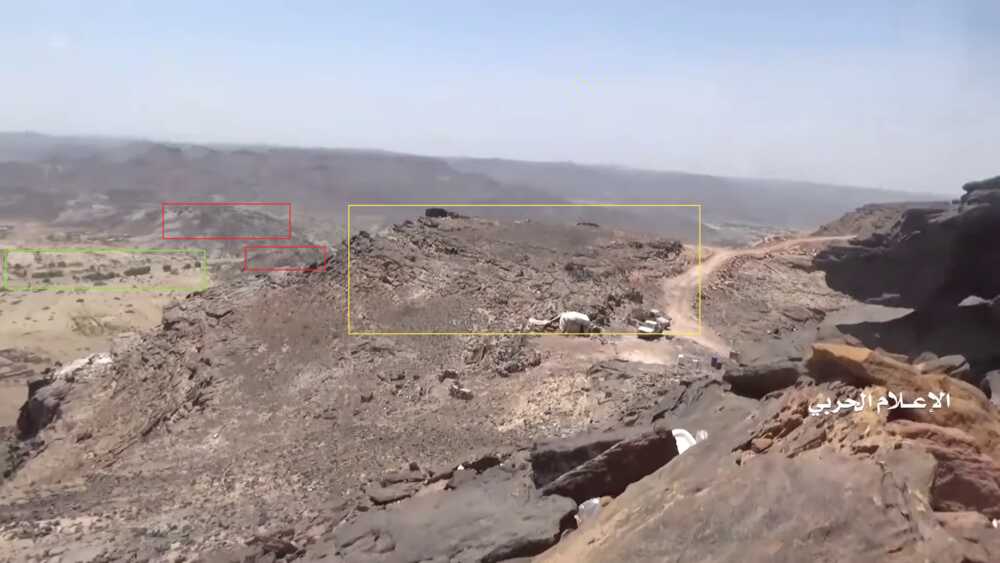
The retreat of the Saudi National Guard towards the Alfare valley did not happen without casualties. The Houthi-made report shows from 23:55 to 27:07 5 destroyed LAVs. 2, possibly 3, of these LAVs are still visible on satellite imagery from 30 May 2020 and were not present on imagery from 21 July 2019. Also the details of the surroundings visible on the video matches with the satellite pictures.
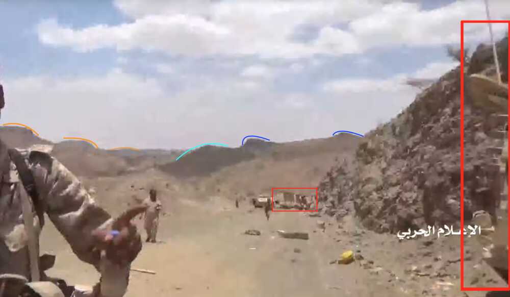
LAV1 and LAV2 are on the satellite image still positioned as seen on the video. The LAV which is driven across the road to block it, and then put on fire, is possibly LAV3 pushed aside of the road. However for this last spot it is difficult to determine if it is indeed the burned-out remnant of a LAV. The 2 LAVs which are seen in the valley near the road, cannot be found anymore on the satellite imagery and have possibly been removed.A first clear detail is the hole (yellow) in the asphalt near LAV1, while also the steep rock along the eastern side of the road matches.
Also the hills visible when looking north from LAV1 to LAV2 match with Google Earth. The most nearby hill (light blue) does deviate from that view, but this possibly due to the not very accurate calculation and smoothing algorithm of this tool.
Similarly the view to the west matches the satellite picture. The steep slope of the mountain side (red) and some buildings in the valley (green) are visible.
-
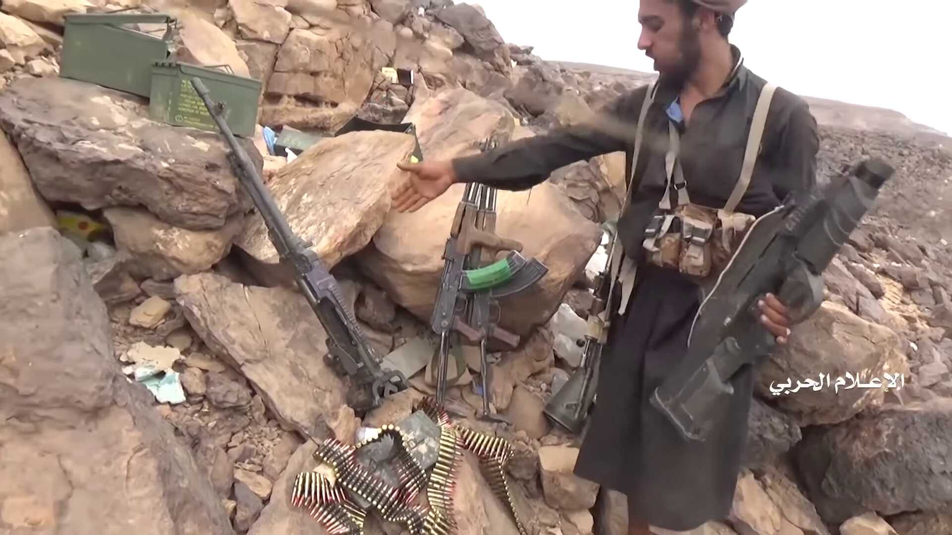
Again, these LAVs show the involvement of the Saudi National Guard in operations inside Yemen. During such operations it also uses its Belgian-made arms, as proven by the F2000 taken by a Houthi soldier from one of the LAVs.

Based on these verified video images we can therefore conclude that the Saudi National Guard was actively engaged in offensive operations in the Jabara valley.
-
the Houthi counter-offensive
In the third phase the Houthi counter-offensive chases the Saudi forces from their positions in the Alfare valley and the outposts it has established in this region. A second Houthi-made video shows a chronological report of the events around the Alfare valley, where the Houthi during several days take over a range of Saudi outposts.
The first day shows the fighting around an outpost situated south of the Alfare valley, while the retreating LAVs are passing by. From this position onwards the Houthi start taking territory from the Saudi military, as we see long-held Saudi positions fall.
-
Destruction M-ATV and outpost before Alfare valley
The Houthi-made report shows the final attacks on the retreating Saudi National Guard forces coming from the Jabara valley and the take-over of the Saudi outpost and positions near the entrance of the Alfare valley.
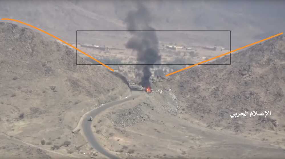
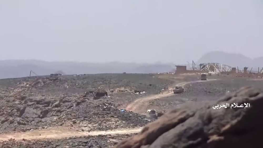
The first part of the Houthi-made video, from 0:42 to 6:24, shows the final attacks on the retreating Saudi National Guard forces coming from the Jabara valley and the take-over of the Saudi outpost and positions near the entrance of the Alfare valley on the road 1556. First we see the LAVs and other vehicles passing, and attacks on them and the position, from viewpoints situated south. Later we see images at the conquered outpost itself from several angles and positions. After this fragment images are shown of tents and mortars in the small valley behind this outpost and before the last hills in front of the Alfare valley (7:05 – 8:05), but we focus in the geolocation on the outpost.
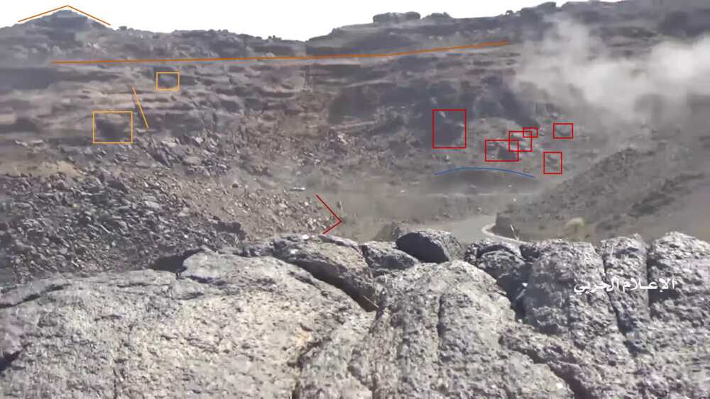
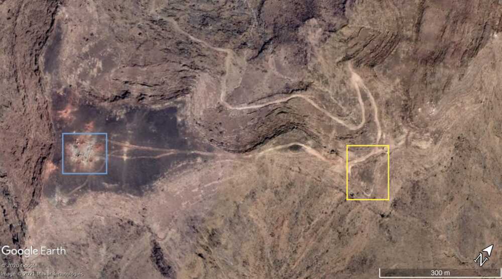
On Google Maps this Saudi position is indicated as a gas station. The nearby mountains and slopes (orange) and the curving road visible throughout the images made at the outpost match with the satellite imagery.
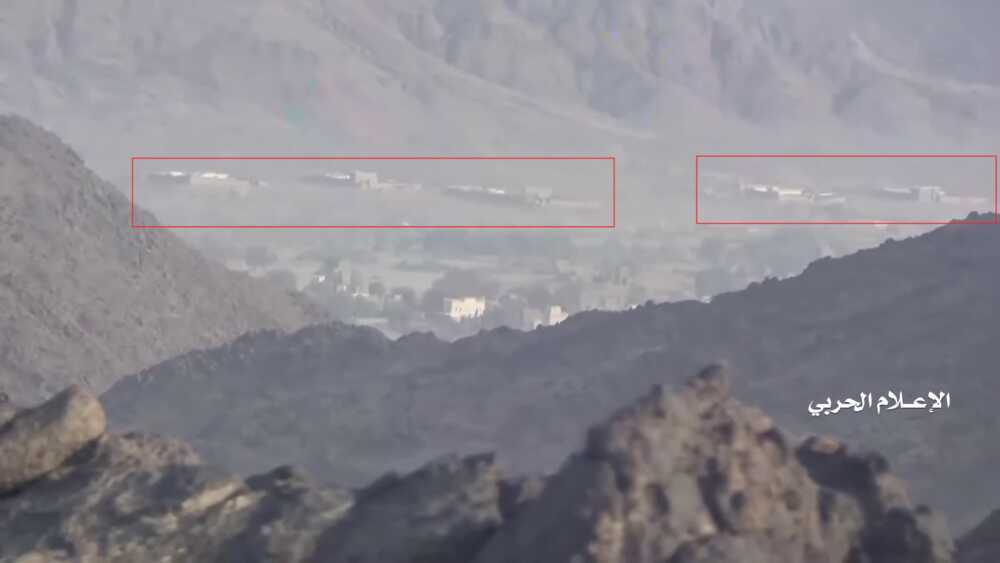
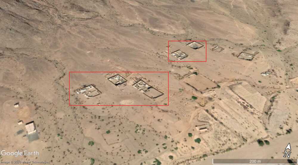
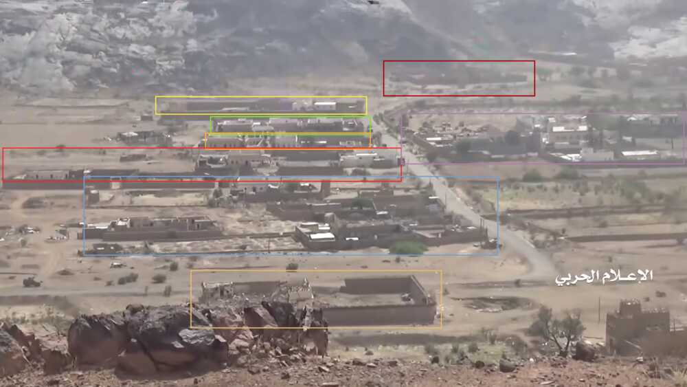
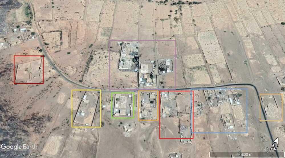
The views on Alfare valley can be matched as well. In the view from the outpost (4:50-4:58) we can recognize 5 compounds (red) situated at the northern side of Alfare valley.
Lastly, also smaller details can also be matched. In the next screenshots made from two different viewpoints several elements can be noticed which are also visible on the satellite picture. Along the upward going road on the right: first several bushes (dark green) partly inside a more light coloured area (light green), a longer landslide with several distinct stones, a set of distinct rocks (purple) and a smaller landslide (white). On the right side of the road a small off-road deviation (yellow) can be seen in the second screenshot. The satellite picture also shows a dark shade on the road at the spot where an immobilized vehicle can be seen in the video (e.g. 6:09-6:15), and can be burning marks.
-
The video shows the presence of a FN-made M2HB machine gun at this position, and probably another one at the hilltop position. A similar M2HB is shown on 9:23-9:29 at another outpost (not geolocated, but probably at the south-east side of Alfare valley). These FN heavy machine guns, which also show up in later parts of the video are therefore standard equipment in these Saudi outposts.
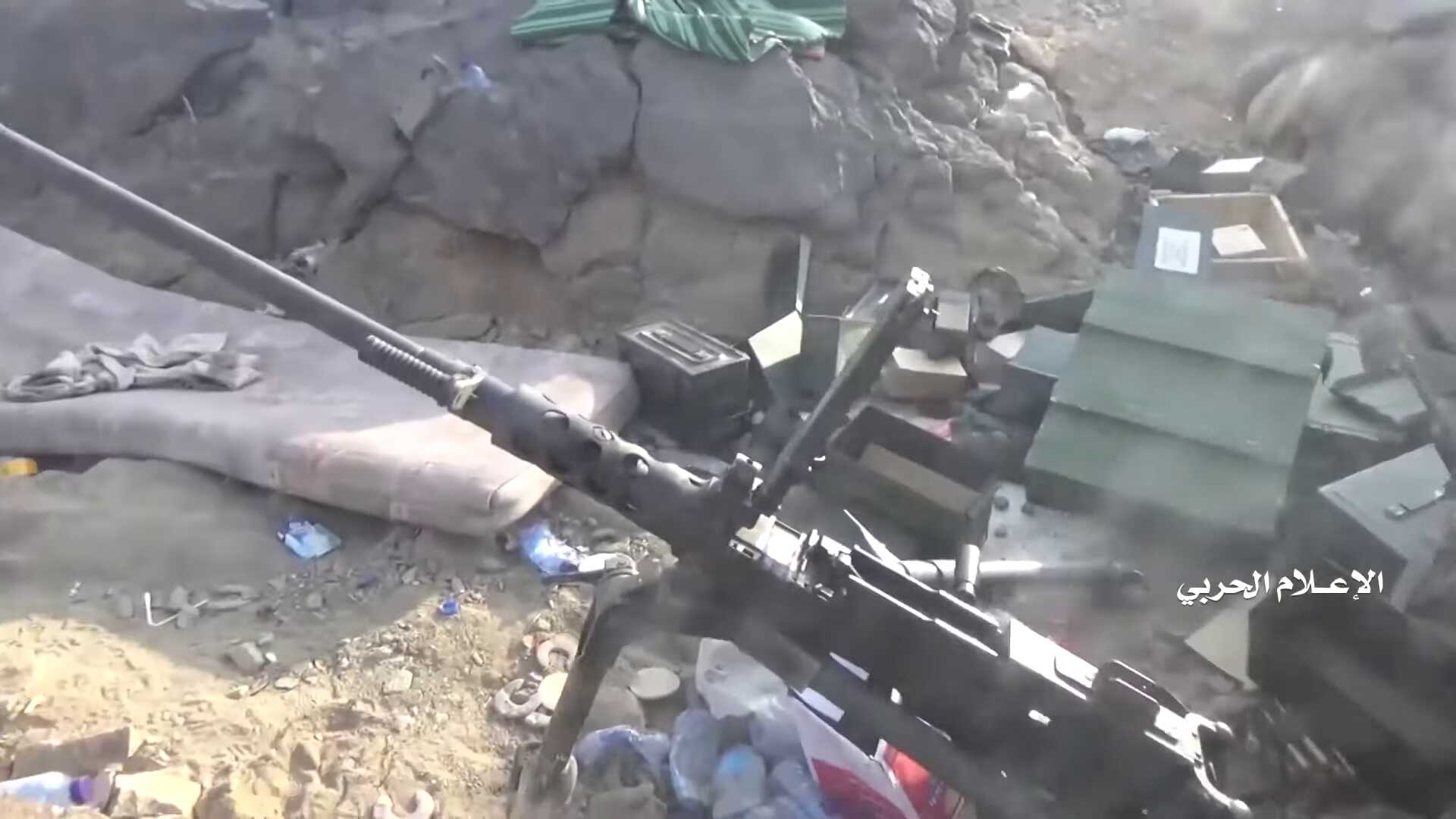
The next day shows a range of fights around the eastern part of the Alfare valley. The Saudi military are attacked inside the valley and are also chased from their positions in the mountains north of Alfare.
-
Outpost north of Alfare valley
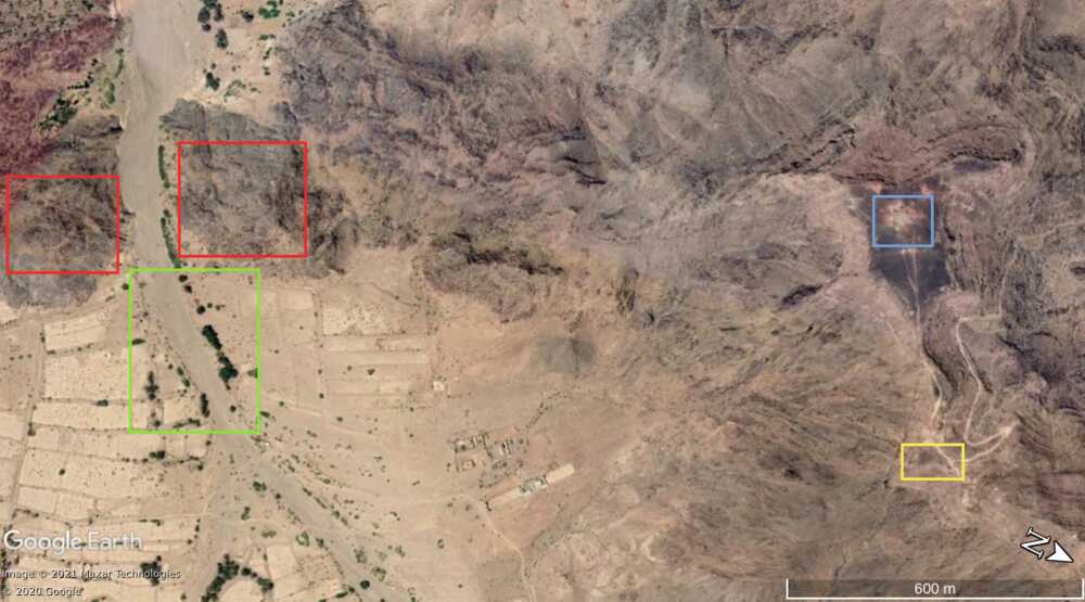
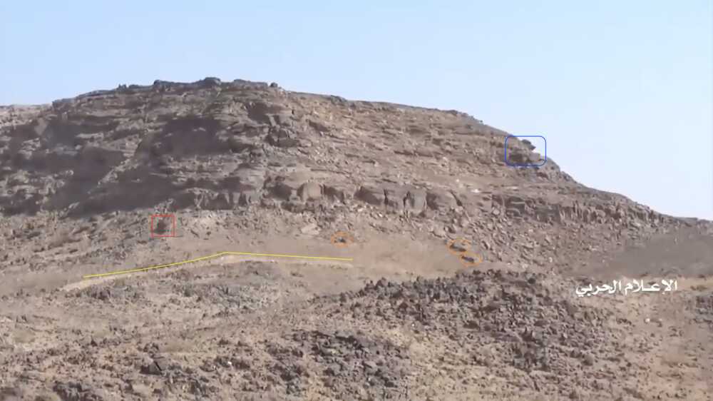
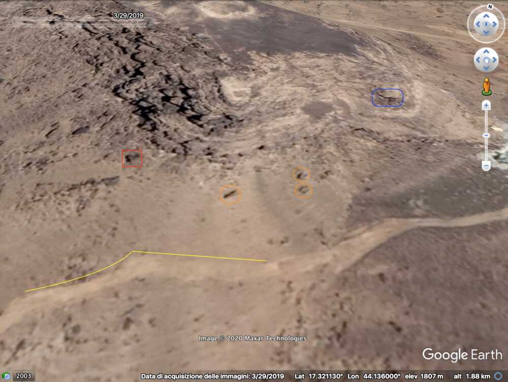
A fragment of this Houthi-made video, from 11:55-13:01, shows the destruction of a Saudi outpost on the mountain north of Alfare valley near an earlier destroyed pylon. This outpost and the pylon can be located on Google Maps.
The video shows a view in 2 directions. The first shows a small plateau (yellow) and a view into the valley, with the hills (red) enclosing the narrow passage between the eastern and western part of Alfare valley. The pattern of the trees (green) visible in the valley matches exactly with the satellite imagery.
The view in the second direction shows the pylon (blue) on a larger plateau, which was destroyed a couple of years earlier.
The location is also confirmed through the video fragment showing a Saudi air raid on the pylon position to counter the Houthi attack, both seen from the valley and from the viewpoint near the outpost (12:21-13:00).
-
Alfare valley
This video shows from 13:37 to 13:55 a view from the hill to the south part of the Alfare valley. The following images till 17:24 shows the reconnaissance done by the Houthi fighters of this part, from where the Saudi military has fled.
These images can be located on Google Maps. -
After this the fighting moves east. The video shows mostly the battle on a large plateau and the destruction of outposts on and nearby this plateau. The Saudi vehicles on the plateau, LAVs and others, are first attacked with anti-tank missiles (20:54-22:42). Later the outpost is taken by Houthi fighters after a fierce exchange of gunfire (22:43-28:44). The remnants of the outpost and positions on the plateau show a wide range of Belgian weapons and ammunition.
-
Saudi outpost on plateau northwest of Alfare valley
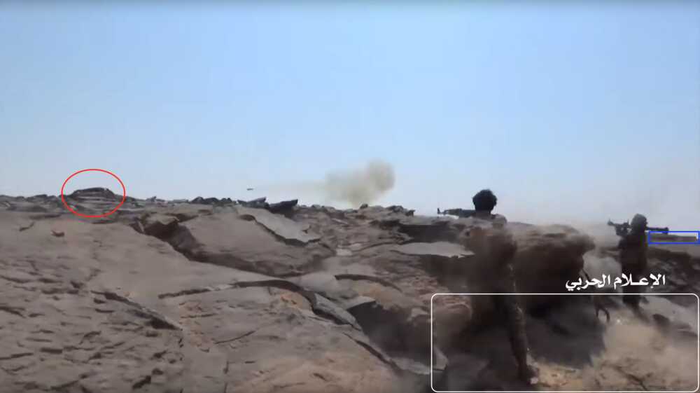
This video shows a battle on a large plateau, including the destruction of an outpost. The Saudi vehicles on the plateau, LAVs and others, are first attacked with anti-tank missiles (20:54-22:42). Later the outpost is taken by Houthi fighters after a fierce exchange of gunfire (22:43-28:44).
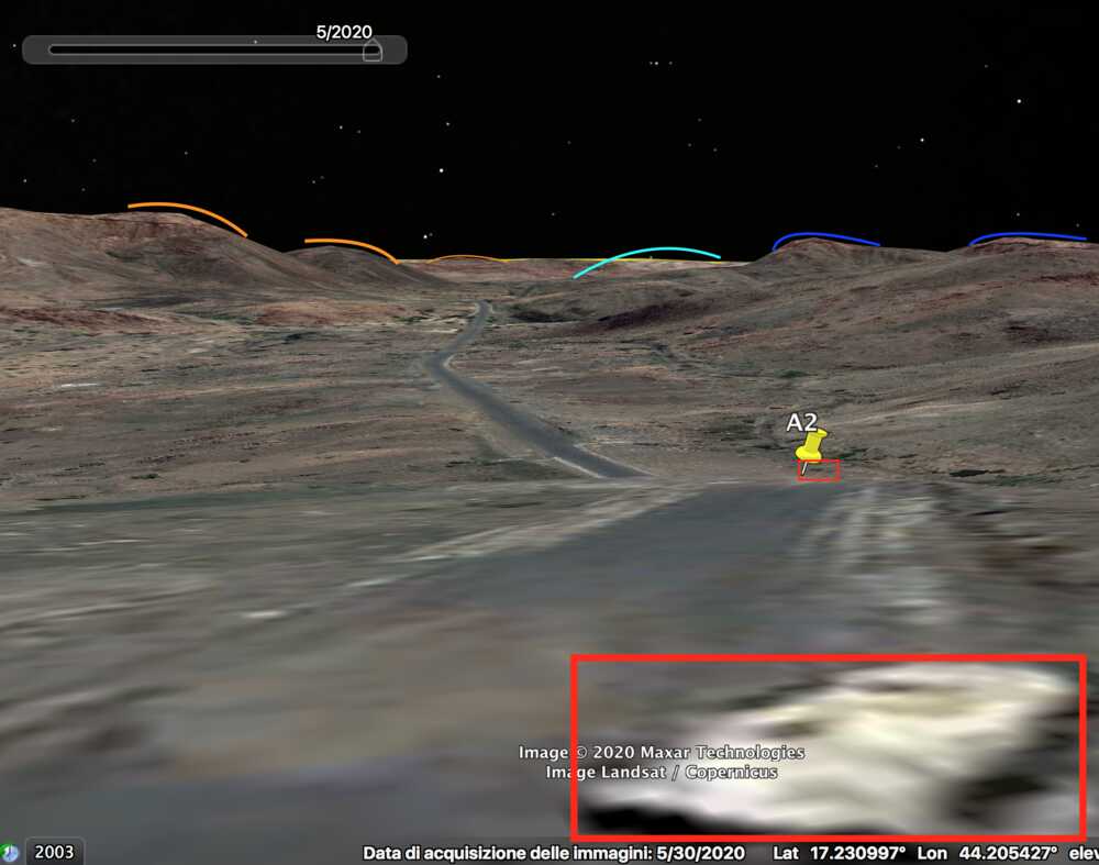
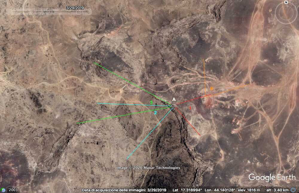
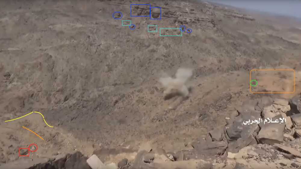
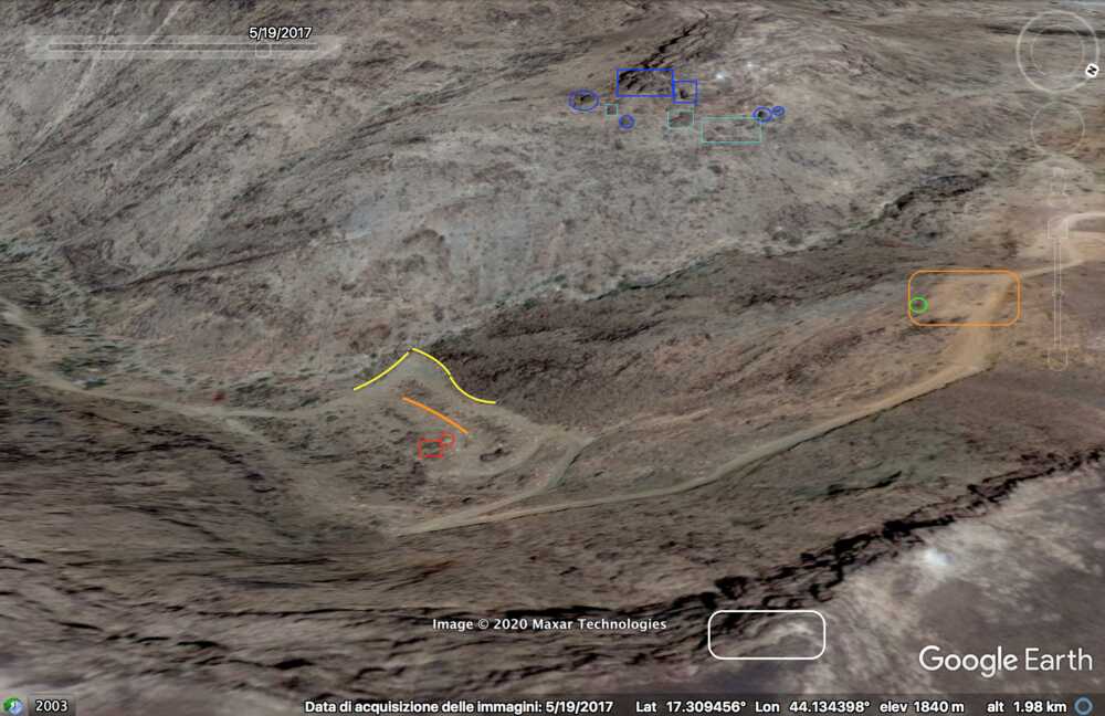
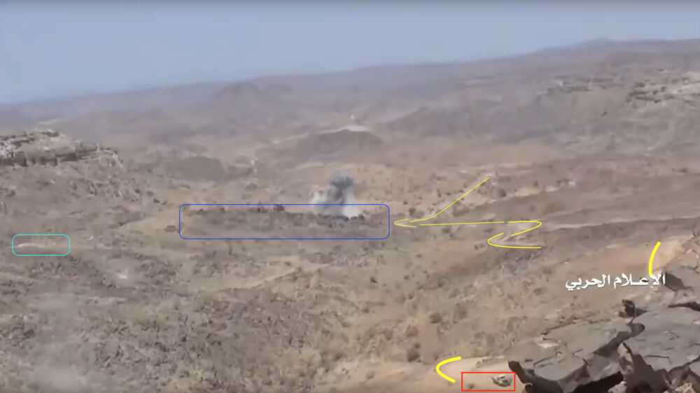
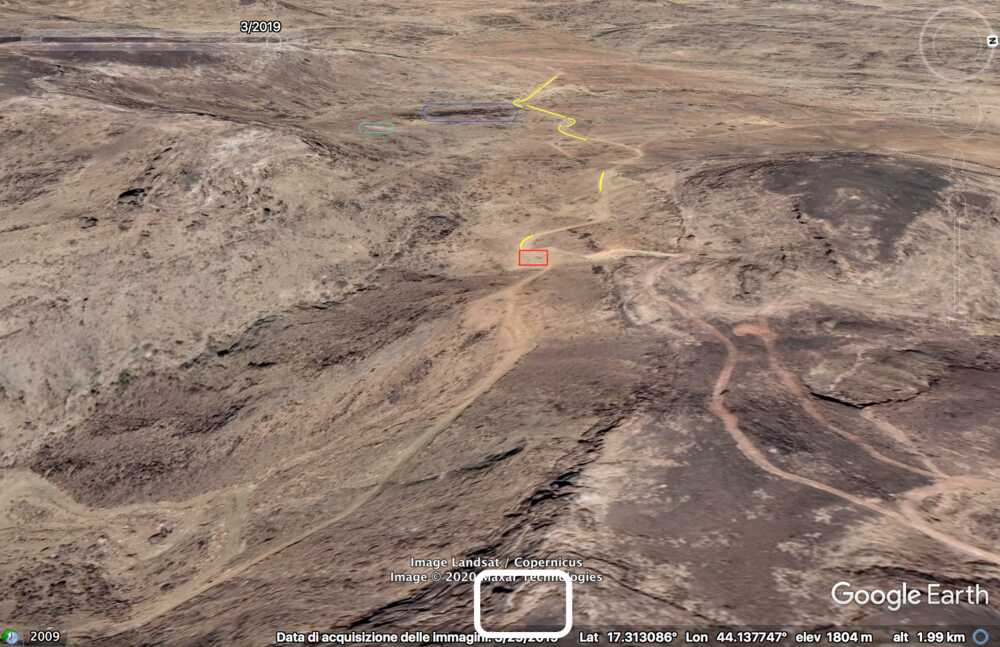
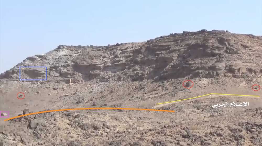
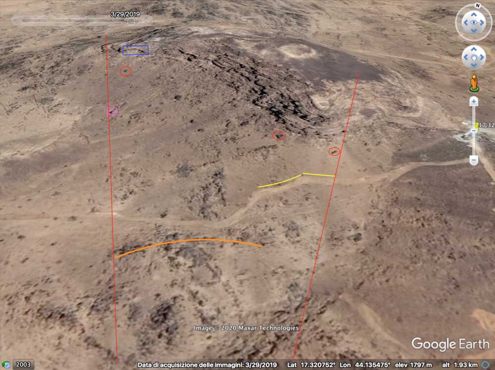
This outpost can be found on Google Maps.The video shows three different perspectives (1, 2, 3) recorded from the same area (A) from which the outpost was attacked.
Further it also shows images recorded from inside the conquered Saudi post (B). The following image shows the perspectives used to verify this location.Point A – Perspective 1
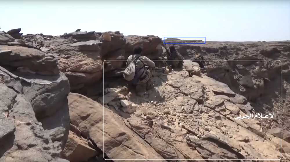
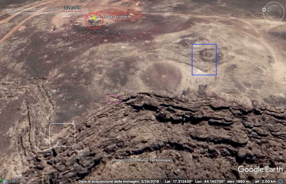
At min 22:59 of the video two Yemeni fighters are shooting at the target Saudi post (red circle). They are standing on a flat stone platform (white) extending from the side of a cliff. The area is shielded by a rock boulder – used as cover – that projects a marked shade on the platform. On the right edge of the frame is possible to spot a flat rock formation (blue) in the distance slightly elevating from the ground.
At min 22:44 the flat natural platform (white) where the fighters are standing and the rock formation (blue) in the distance are more visible. The rock formation has a long and sharp edge, and a small hill rises on its left area.
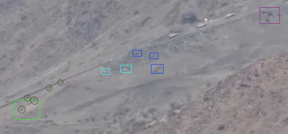
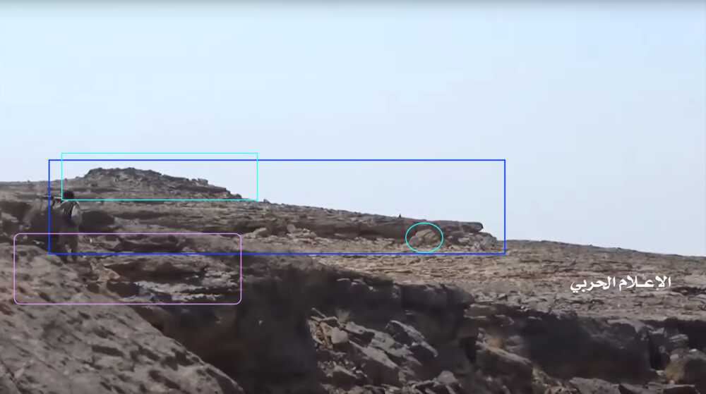
At min 23:34 the same rock formation is displayed in greater detail. On the left of the frame, a Yemeni fighter firing toward the Saudi post stands on a second, smaller, natural platform (purple), which is spottable by satellite; further back appears the flattish rock elevation with sharp edges (blue), with the taller elevation on its left portion (light blue square). A roundish rock (light blue circle) next to the elevation's edge, close to its right end, provides an extra identifiable element.
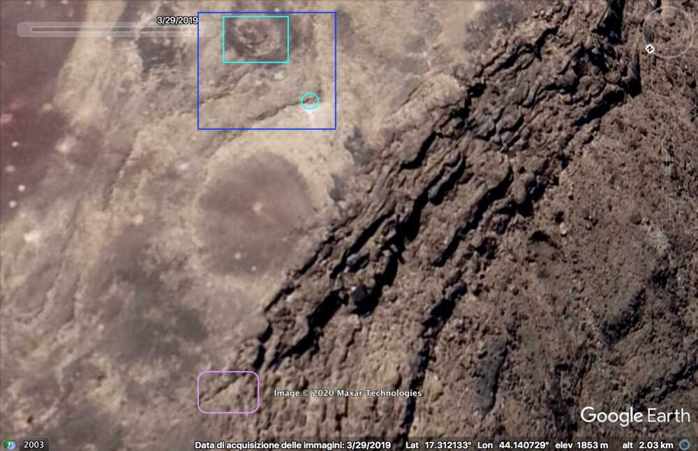
These natural features can be spotted on the satellite images.
A wider satellite image shows all the elements identified so far: Saudi post (red), main natural platform (white), second smaller platform (purple), elevation with hill and sharp edges (blue).
Point A – Perspective 2
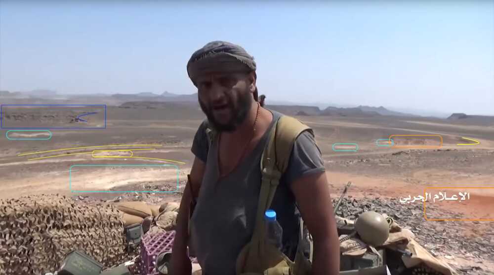
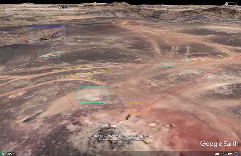
At 24:23 the Yemeni cameraman turns southwest to record the explosion of – likely – an artillery shot. This allows to identify several elements in the adjecent canyon; from left to right: squared and round rocks (red), linear ground shape (orange line), pointy road (yellow), opposite cliff's rocks (blue), smaller rocks (light blue), a tree (green) next to a flat dusty area (orange square).
Point A – Perspective 3
Later, at 24:33, the camera shifts toward West and focuses on an explosion in the far distance. Close to the viewer it's possible to spot a pickup and a rock (red) on the opposite side of the road (yellow).
The road is visible only in portions, but the overall shape can be identified through satellite. The central part is occupied by a dark elevation (blue), aligned with a pale mark on the ground on the left (light blue).
On the satellite picture the viewpoint A is indicated (white) as well. A pickup is only visible on the images of March 2019. This can of course be a different pickup, but it shows this is a regularly used position.Point B
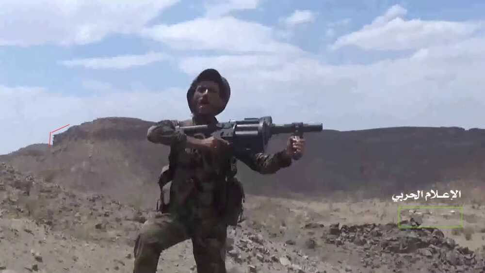
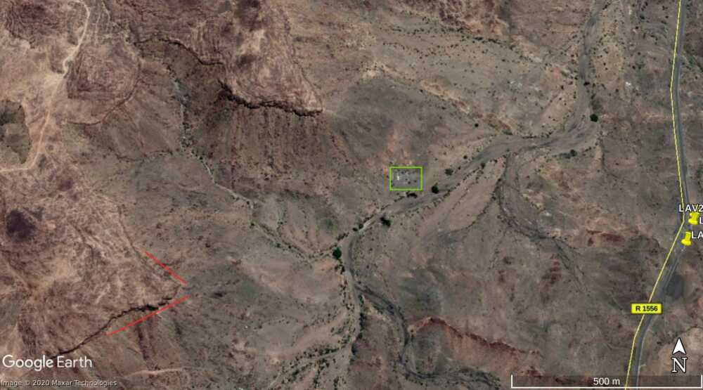
Later in the video the Yemeni fighters conquer the target position and start recording from the inside the post. At min 26:19, several elements in the plane behind the post can be identified. On the left from the top: a bracket-shaped cliff in the distance (blue), a whitish area on the ground (light blue), three tracks in a specific pattern (yellow) and a second whitish area (light blue). On the right two white spots (light blue) are aligned to some loose ground (orange) and the left turn of a track (yellow), and below, in the foreground, an area of dark red soil (orange).
-
Similar scenes follow for attacks on nearby outposts, overlooking a passage between the edge of the plateau and a nearby smaller plateau. The next day we get a close-up of this outpost (32:28-35:16), equipped with a large amount of these weapons and littered with ammunition packages.
-
2nd Saudi outpost northwest of Alfare valley
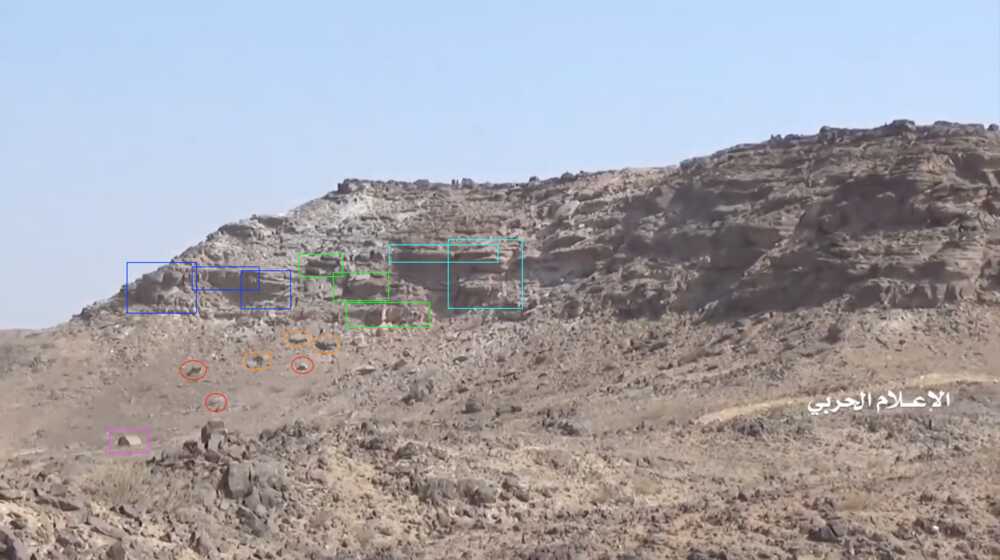
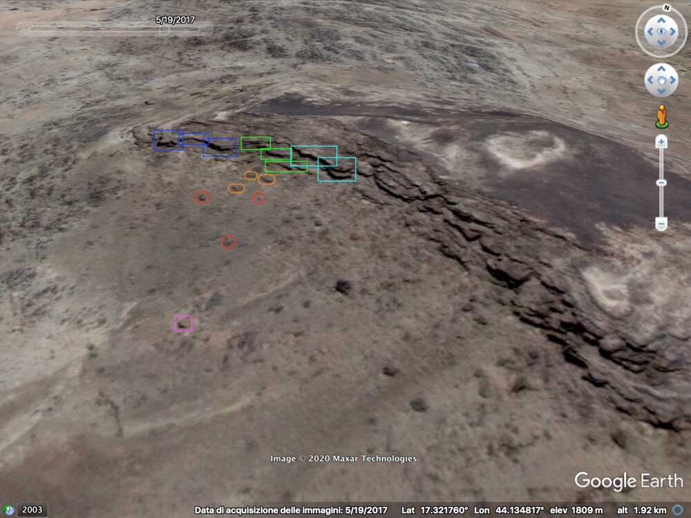
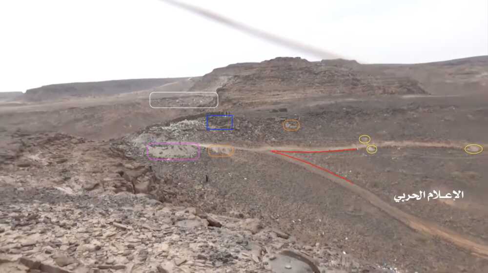
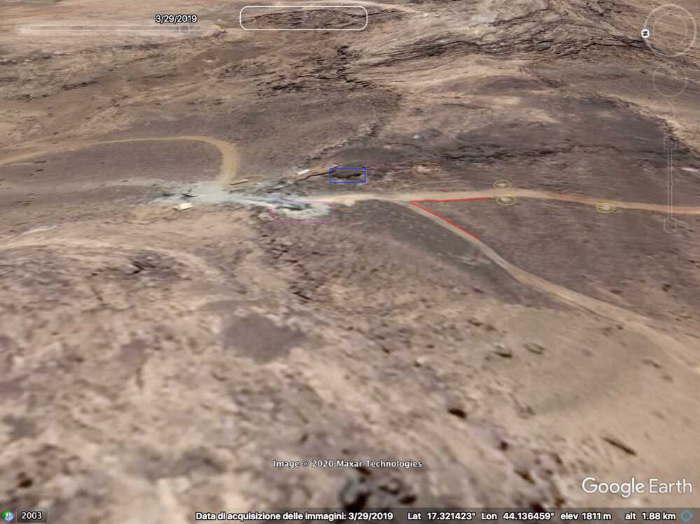
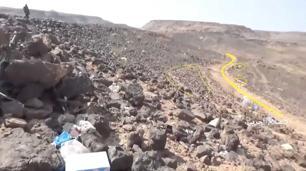
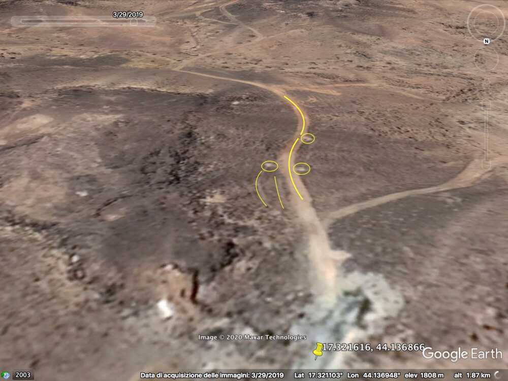
The last part of the video shows an outpost overlooking a passage between the edge of the plateau and a nearby smaller plateau and consisting of positions on both sides. First we see attacks on the outpost, and further a close-up view of the conquered positions. The outpost can be found on Google Maps.
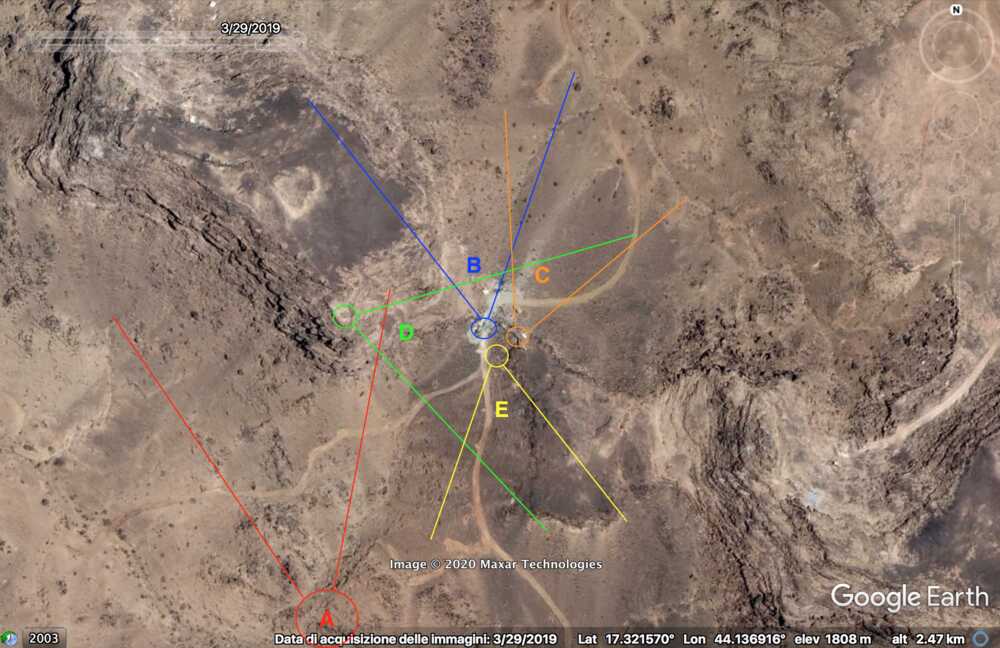
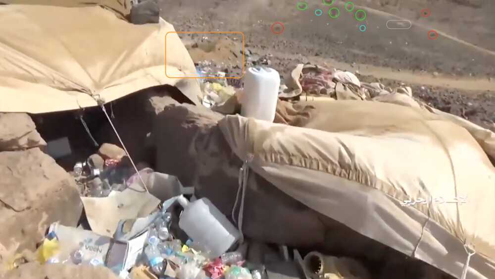
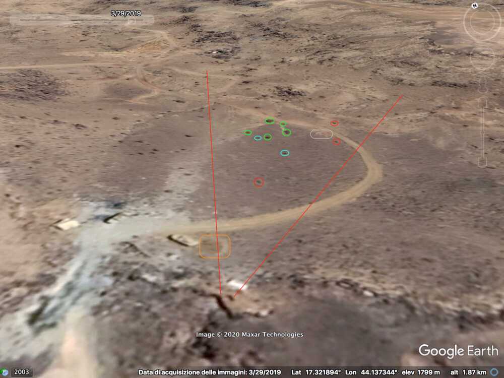
The video shows five different perspectives (A, B, C, D, E) recorded around the same area (the locations indicated are an approximation based on the perspectives in the video). The post rises on a pass between two elevations; on satellite footage (captured on 03/2019) it is possible to spot large military vehicles close by, indicating it was likely used as regular guardpost by the Saudis. The Yemeni footage confirms this assumption. It additionally shows a large quantity of expended cases of different calibers (B) and an ammunition storage (C) close by.
Perspective A
The first frame located was recorded at min 32:32. It shows only a portion of track (yellow), which is covered on the left side by a small hill (orange). In the central right part of the image two rocks (red) are highlighted as reference, while on the left side, behind the hill, it is possible to spot a squared stone (purple), a pointy rock (red) and a peculiarly shaped boulder (blue).
To further verify this location, two additional frames are used focusing on the left and right side of the initial image. At 32:33 – left side – three different patterns in the boulder ( blue, green, light blue) and two triplets of stones ( red and orange) are identified that can also be spotted by satellite. The squared stone (purple) is used as reference for the first image.
For the right side – min 32:36 – the track (yellow) and the two rocks above are used as reference. The left rock (red) is indicated as in the overall image for Perspective A. For the second rock a different color is used as it creates an evident pattern with the two rocks on its right (orange). Additionally, the pointy cavity on the boulder (blue) can be spotted from satellite as it creates a distinct shade on the wall.
PERSPECTIVE B
The frame at 32:51 of the video mainly shows the vast amount of expended Saudi cases, but some elements can be spotted on the top right corner: a white tent (blue) just behind the side of the hill, a track (yellow) far in the background going North with a greenish area (green) on the left of its initial portion and two rocks (red) on the right side. Additionally, on the right of the two rocks, a dark arch-like disposition of smaller rocks (white) can be spotted.
PERSPECTIVE C
At 33:00 the Yemeni cameraman is entering the Saudi munition storage. Some elements of the background can be spotted on the top part of the image and identified in relation to the pale track, which takes a long and smooth curve to the left: a small mound of ground (orange), two small shrubs (light blue) followed by five shrubs (green) in a specific pattern, a whitish area (white) next to the road and aligned with the shrubs, and three rocks (red) that can be spotted by satellite.
PERSPECTIVE D
This perspective was likely recorded from the top of the left elevation of the area. At min 35:10 several elements have been identified to verify this location: two converging tracks (red), along the top track three whitish areas (yellow), two additional whitish spots (orange), a small slope next to the used cases (purple), a small boulder (blue) and a big landslide in the background (white).
PERSPECTIVE E
The last geolocation is a different perspective of the top track of Perspective D. At min 32:54 the cameraman is facing South; the track has the same disposition of whitish areas (yellow circles) and follows the same pattern: smooth curve to the right then smooth curve to the left (thick yellow). Additionally, two small marks (thin yellow) can be spotted by satellite in relation to the top whitish area indicated earlier.
-
Remnants and wreckages of LAVs and other vehicles can still be found on the satellite pictures, also in areas not identified in the video. Therefore we can assume that similar battles took place at other spots as well.
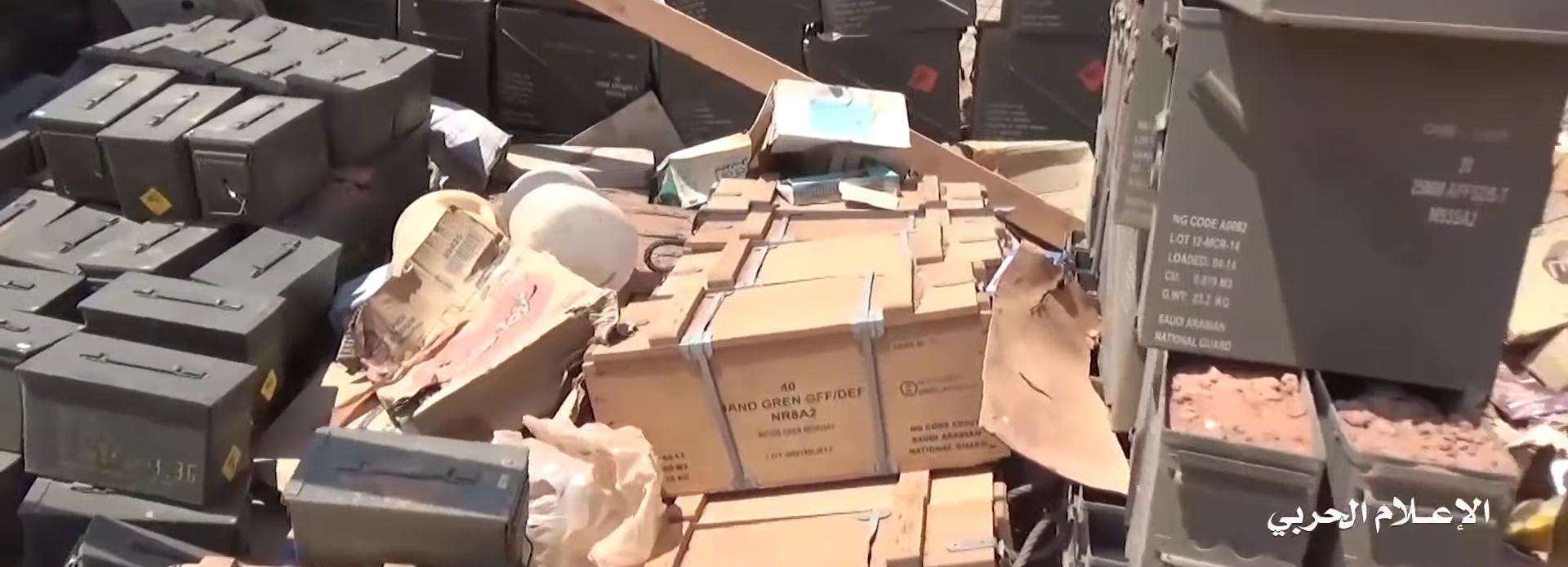
image: Yemen Wrath
Conclusion
We can conclude from this investigation that the Saudi National Guard is clearly performing military operations inside Yemen. The presence of the LAVs, a military vehicle only used by the National Guard, proves their involvement in the operation towards the Jabara valley end July 2019 and at a range of positions in the north of Yemen. Small arms and light weapons used by these Saudi troops to a large extent have been produced in and exported from Belgium.
The Belgian Council of State, the main administrative court, has suspended twice export licences for similar material from FN and Mecar based on the risk that this material could be used in Yemen. Each time the Walloon government has simply withdrawn the licence and promptly started a new licencing process, the last time on 24 November 2020. It is unknown at the moment whether new licenses have been granted. (UPDATE: Via Le Soir and Knack we received the information that the Walloon government has granted again new export licences to FN.) This investigation shows that the risk indicated by the Council of State is well-founded. Any new military exports can be expected to show up in military operations in Yemen and any new export licences will therefore have the same defects.
Thanks
To this investigation have contributed: Hans Lammerant, Daniel Sidoli, Laura Silvia Battaglia and the participants in the Vredesactie OSINT workshop on 17 October 2020.
However, the interpretations and views expressed in and the content of this publication is the sole responsibility of Hans Lammerant, Vredesactie.
+12.7(down).jpg)
